Independent Survey Project Details
Independent survey projects involve building and archaeological surveys that are not conducted as part of a consultation project.
For information on how to submit an independent survey project to SHPO, see the Submit a New Independent Survey Project help page.
You can open the details module for an independent survey project in the following ways:
- Search for the project and click the View button for the project in the Results tab. You must have special privileges to search for independent survey projects. This functionality is generally only available to preservation personnel in state and federal agencies.
- Use the Find My Project form on the guest user Home page to search for the project.
- Find the project in the My Projects tab on your dashboard and click the View button.
- Open an Answer a Question page or consolidated response page pertaining to the project and click the View Project button.
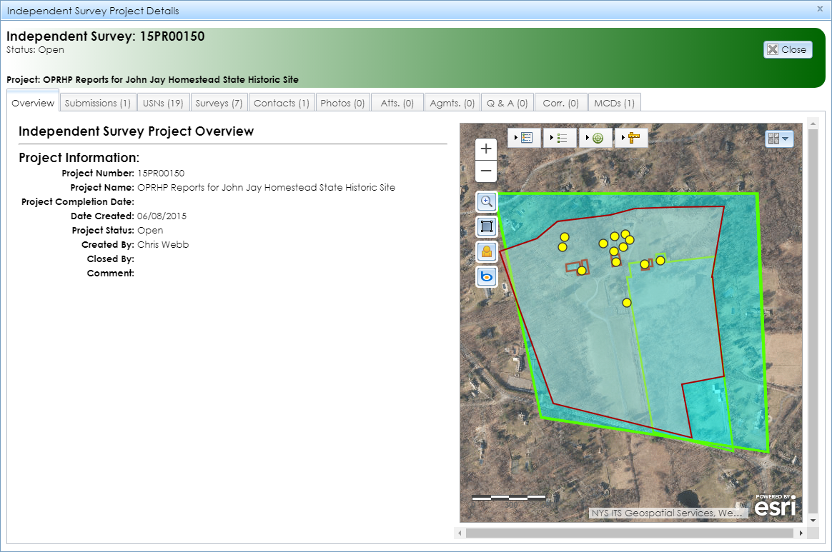
The Independent Survey Project Details module uses the same basic design as for other project types, with the addition of the Surveys tab. When you open the module, it will display with the Overview tab open by default, as shown below.

-
Overview: Standard tab containing basic information about the project, as well as a map interface that zooms to the survey boundaries, which will be highlighted in light blue. If no survey boundaries are mapped for the project, the message
The Survey Areas do not exist in the GIS
will display above the project information.
-
Project Information
- Project Number: SHPO’s project identifier in the format 16PR08851, where 16 is a 2-digit year (2016 in this example) and 08851 is a 5-digit sequence number.
- Project Name
- Project Completion Date: The date on which SHPO last closed the project. Independent survey projects may be closed after SHPO has finished reviewing and processing the surveyed built resources or archaeological sites.
- Date Created: The date on which SHPO accepted the project’s initial submission and created the project record in CRIS.
-
Project Status: The status of the project’s review.
- Open: The project is currently under review by SHPO.
- Closed: SHPO’s review of the project is complete.
- Re-opened: SHPO’s review of a previously closed project has resumed.
- Created By: The name of the SHPO reviewer who accepted the project’s initial submission and created the project record in CRIS.
- Closed By: The name of the SHPO reviewer who closed the project.
- Comment: A free-text field for miscellaneous comments about the project.
- Submissions: Standard tab containing a table of the project’s submissions, including the status, dates, and reviewers.
- USNs: Standard tab showing USNs that are linked to the project, as well as submitted resources that were included in project submissions. Click the View (magnifying glass) button to open a USN or submitted resource.
- Surveys: Surveys that were reviewed for the project. Click the View (magnifying glass) button to open the Survey Details module.
Note: Archaeological surveys are available only to CRIS users with archaeological data access privileges. To apply for archaeological permissions, please complete the PDF application form and email the form with supporting documentation (if applicable) to CRISHelp@parks.ny.gov with the subject “Archaeology Permission Request.”
You will need to log into CRIS with an NY.gov ID account at least once before SHPO can enable archaeological permissions for your user profile.
- Contacts: Standard tab showing a list of contacts who are linked to the project. Click the View (magnifying glass) button to open a contact record. If you are the project’s primary contact and an authenticated user, you may add a contact, edit an existing contact, or designate another contact as the primary contact.
- Photos: Standard tab showing photographs pertaining to the project. Photographs for independent surveys are typically included in the submitted resource and USN records or in the survey reports, rather than in this tab. Click the View (magnifying glass) button to view or download the full-resolution image.
- Attachments (Atts.): Standard tab containing documentation pertaining to the project. Survey reports will not be stored here; you may view them by opening each survey from the Surveys tab.
- Agreements (Agmts.): Standard tab containing agreement documents between SHPO and other stakeholders. (This is typically used for consultation projects.)
- Q & A: Standard tab containing a table of SHPO questions pertaining to the project.
- Correspondence (Corr.): Standard tab with a table of correspondence records for the project.
- MCDs: Standard tab listing one or more counties and minor civil divisions (MCDs) in which the project’s surveys are located. MCDs include cities, towns, villages, reservations, and boroughs.
