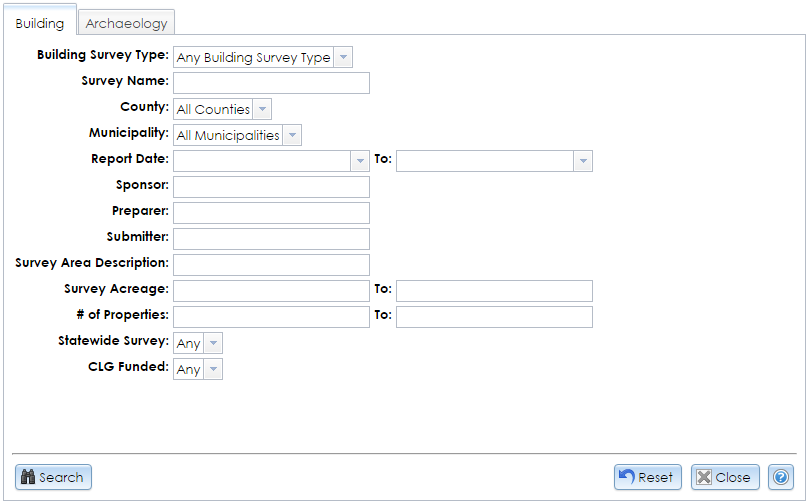
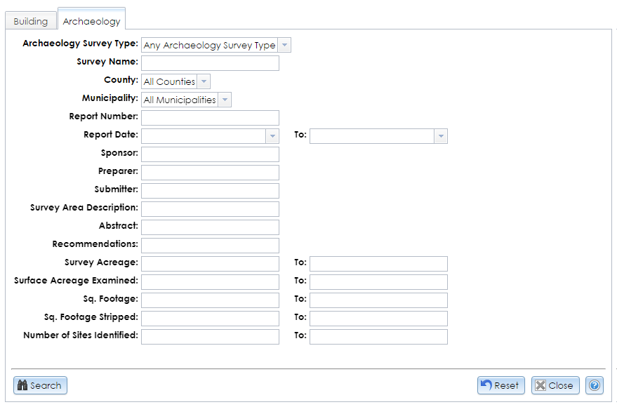
The Advanced button in the Survey search tab opens a module with advanced search options for the two main survey types, Building and Archaeology. Each tab has an independent Reset button that resets the fields to their default values in that tab only.
You do not need to fill all of the fields. If you enter search terms in multiple fields, only results that exactly match all of your search terms will be returned. Letters can be upper or lower case. In text fields, partial search terms are acceptable; for example, searching the Survey Name ridge will return surveys with names like King Bridges in New York State and Bay Ridge.
Click the Search button in the lower left corner of the module to apply your search terms. The Results tab will display your search results. Click the View (magnifying glass) button next to a survey result to open the Survey Details module.
Building
In the Advanced Survey Search module, the Building tab mostly comprises fields in the Overview tab of the Survey Details module.

- Building Survey Type: Select from the dropdown list or leave the default value, Any Building Survey Type. Reconnaissance and Intensive surveys, which are the most common types inventoried by SHPO, are defined by the National Park Service in Chapter I of National Register Bulletin 24, Guidelines for Local Surveys: A Basis for Preservation Planning. A Context Study, which is less common, is a historical overview of the overarching forces (environmental, geographical, social, cultural, political, governmental, technological, etc.) that have shaped land use patterns and development of the built environment of the area under consideration. It establishes the historical significance of properties associated with particular themes.
- Survey Name: The title of the survey. Since spelling or naming conventions may differ, you may wish to enter only part of the name to increase the chance of finding a match.
- County: The county that contains the survey. Select the county name or leave the default, All Counties. If a survey is located in multiple counties, a search for any one of its counties will retrieve it.
- Municipality: The minor civil division (MCD) that contains the survey. MCDs may be cities, towns, villages, reservations, or boroughs. You must select a county before you can select an MCD from the list. If a survey is located in multiple MCDs, a search for any one of its MCDs will retrieve it.
- Report Date: The date on which the survey was completed. You may either type the date or click the dropdown button and use the calendar tool to select the date. You may enter a start date, an end date, or both. If you leave the start date blank, surveys completed before the end date will be returned. If you leave the end date blank, surveys completed after the start date will be returned.
- Sponsor: The name of an organization or other party that sponsored the survey.
- Preparer: The last name of the person who prepared the survey.
- Submitter: The last name of the person who submitted the survey to SHPO.
- Survey Area Description: The description of the survey boundary.
- Survey Acreage: Specify a range for the number of acres covered by the surveys you wish to search. You may enter a lower bound, an upper bound, or both. If you leave the lower bound blank, surveys that are smaller than the upper bound will be returned. If you leave the upper bound blank, surveys that are larger than the lower bound will be returned.
- # of Properties: Specify a range for the number of properties in the surveys you wish to search. You may enter a lower bound, an upper bound, or both. If you leave the lower bound blank, surveys that have fewer properties than the upper bound will be returned. If you leave the upper bound blank, surveys that have more properties than the lower bound will be returned.
- Statewide Survey: Select Yes to return surveys that include built resources throughout New York State, or select No or leave the default value, Any.
- CLG Funded: Select Yes to return surveys that were funded by the Certified Local Government program, or select No or the default value, Any.
Archaeology
In the Advanced Survey Search module, the Archaeology tab mostly comprises fields in the Overview tab of the Survey Details module. This search tab is available only to CRIS users with archaeological data access privileges.
To apply for archaeological permissions, please complete the PDF application form and email the form with supporting documentation (if applicable) to CRISHelp@parks.ny.gov with the subject “Archaeology Permission Request.” You will need to log into CRIS with an NY.gov ID account at least once before SHPO can enable archaeological permissions for your user profile.

- Archaeology Survey Type: Select the survey category from the dropdown list. Generally, surveys will be categorized as Phase I (divided into IA and IB), II, or III. These phases are defined on SHPO’s Environmental Review: Archeological Surveys page. The category list also includes addendum surveys for each phase, combinations of phases, geomorphology, monitoring, and remote sensing, among other types.
- Survey Name: The title of the survey. Since spelling or naming conventions may differ, you may wish to enter only part of the name to increase the chance of finding a match.
- County: The county that contains the survey. Select the county name or leave the default, All Counties. If a survey is located in multiple counties, a search for any one of its counties will retrieve it.
- Municipality: The minor civil division (MCD) that contains the survey. MCDs may be cities, towns, villages, reservations, or boroughs. You must select a county before you can select an MCD from the list. If a survey is located in multiple MCDs, a search for any one of its MCDs will retrieve it.
- Report Number: The “shelf number” that SHPO formerly used for organizing surveys within counties. This number appears in the survey coverage maps and bibliography sheets that are available to archaeology-enabled users through the CRIS Library. Note that this field searches within values, so searching 56 will return 56, 256, 569, and so on.
- Report Date: The date on which the survey was completed. You may either type the date or click the dropdown button and use the calendar tool to select the date. You may enter a start date, an end date, or both. If you leave the start date blank, surveys completed before the end date will be returned. If you leave the end date blank, surveys completed after the start date will be returned.
- Sponsor: The name of an organization or other party that sponsored the survey.
- Preparer: The last name of the person who prepared the survey.
- Submitter: The last name of the person who submitted the survey to SHPO.
- Survey Area Description: The description of the survey boundary.
- Abstract: The summary of the investigations performed in the survey and the resulting findings.
- Recommendations: The survey’s results or implications for further investigations.
- Survey Acreage: Specify a range for the number of acres covered by the surveys you wish to search. You may enter a lower bound, an upper bound, or both. If you leave the lower bound blank, surveys that are smaller than the upper bound will be returned. If you leave the upper bound blank, surveys that are larger than the lower bound will be returned.
- Surface Acreage Examined: Specify a range for the number of acres that underwent surface examination (after plowing or disking) in the surveys you wish to search. You may enter a lower bound, an upper bound, or both. If you leave the lower bound blank, surveys that have fewer examined acres than the upper bound will be returned. If you leave the upper bound blank, surveys that have more examined acres than the lower bound will be returned.
- Sq. Footage: Specify a range for the number of square feet that were hand-excavated in Phase II or III investigations. You may enter a lower bound, an upper bound, or both. If you leave the lower bound blank, surveys that have less excavated area than the upper bound will be returned. If you leave the upper bound blank, surveys that are have more excavated area than the lower bound will be returned.
- Sq. Footage Stripped: Specify a range for the total mechanically stripped area in square feet. You may enter a lower bound, an upper bound, or both. If you leave the lower bound blank, surveys that have smaller stripped areas than the upper bound will be returned. If you leave the upper bound blank, surveys that have larger stripped areas than the lower bound will be returned.
- Number of Sites Identified: Specify a range for the number of sites identified in the surveys you wish to search. You may enter a lower bound, an upper bound, or both. If you leave the lower bound blank, surveys that have fewer sites identified than the upper bound will be returned. If you leave the upper bound blank, surveys that have more sites identified than the lower bound will be returned.

