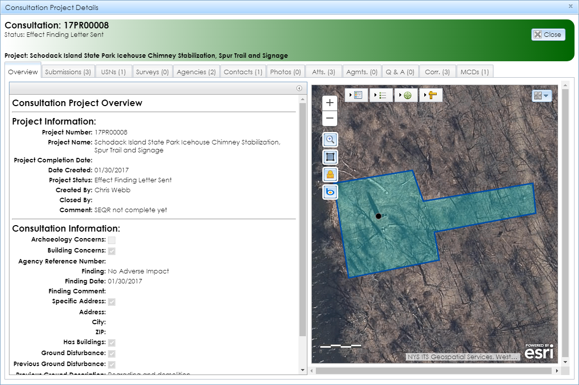
The Overview tab displays by default when you open the Consultation Project Details module, as shown below. This tab contains the map interface on the right, with the project’s area of potential effect (APE) highlighted in light blue. If the project is not yet mapped, the map will zoom out to New York State and the message The Project Area Boundary does not exist in the GIS
will display above the project information.
If at least one of the project’s USNs has a preservation covenant or easement, the message Check Agreements tab for covenants/easements
will display above the project information. You can access the agreement record and documentation in the Agreements (Agmts.) tab.
On the left is a list of fields that provide basic information about the project.
-
Project Information
- Project Number: SHPO’s project identifier in the format 16PR08851, where 16 is a 2-digit year (2016 in this example) and 08851 is a 5-digit sequence number.
- Project Name
- Project Completion Date: The date on which SHPO last closed the project. Consultation projects are usually closed when SHPO renders an impact or effect finding. The finding letter will be available under the Attachments (Atts.) tab.
- Date Created: The date on which SHPO accepted the project’s initial submission and created the project record in CRIS.
-
Project Status: The status of the project’s review.
- Open: The project is currently under review by SHPO.
- Effect Finding Letter Required: SHPO has rendered a finding for the project, but has not yet uploaded the finding letter to CRIS.
- Effect Finding Letter Sent: SHPO has sent the finding letter to the project contacts, but has not yet marked the project as Closed.
- Closed: SHPO’s review of the project is complete. Some pre-CRIS projects were closed automatically if no submissions had been received for several years.
- Re-opened: SHPO’s review of a previously closed project has resumed. This may be due to changes to the project’s scope of work or APE.
- Created By: The name of the SHPO reviewer who accepted the project’s initial submission and created the project record in CRIS.
- Closed By: The name of the SHPO reviewer who closed the project.
- Comment: A free-text field for miscellaneous comments about the project.
-
Consultation Information
- Archaeology Concerns: Whether the project has the potential to impact or affect archaeological resources. This field is set to True (checked) by default for projects in which the applicant indicated proposed ground disturbance. The field is set to False (unchecked) if there is no proposed ground disturbance or if the SHPO Archaeology Unit reviewer signed off with No Archaeological Concerns.
- Building Concerns: Whether the project has the potential to impact or affect built resources. This field is set to True (checked) by default for projects in which the applicant indicated that built resources are present in the APE. The field is set to False (unchecked) if there are no built resources in the APE or if the SHPO Survey and National Register Unit reviewer signed off with No Building Concerns.
- Agency Reference Number: The reference number for the project used by a non-SHPO agency or organization, if applicable.
-
Finding: SHPO’s impact or effect finding for the project.
-
State (New York State Historic Preservation Act Section 14.09) reviews:
- No Historic Properties Impacted: Historic properties are not present in the project area, or historic properties are present, but the proposed undertaking will not impact their historic integrity.
- No Adverse Impact: Historic properties are present, and the proposed undertaking will impact their historic integrity, but not in an adverse manner.
- Adverse Impact: Historic properties are present, and the proposed undertaking will impact their historic integrity in an adverse manner.
- No Adverse Impact with Conditions: Historic properties are present, and the proposed undertaking will impact their historic integrity, but SHPO does not consider the impact adverse if specific conditions are followed.
-
Federal (National Historic Preservation Act Section 106) reviews:
- No Historic Properties Affected: Historic properties are not present in the project area, or historic properties are present, but the proposed undertaking will not affect their historic integrity.
- No Adverse Effect: Historic properties are present, and the proposed undertaking will affect their historic integrity, but not in an adverse manner.
- Adverse Effect: Historic properties are present, and the proposed undertaking will affect their historic integrity in an adverse manner.
- No Adverse Effect with Conditions: Historic properties are present, and the proposed undertaking will affect their historic integrity, but SHPO does not consider the effect adverse if specific conditions are followed.
- No Effect: Historic properties are present, but the proposed undertaking will not affect their historic integrity.
- Finding Date: The date on which SHPO issued its most recent impact or effect finding.
- Finding Comment: SHPO’s comments about the finding.
- Specific Address: Whether the project is located at a specific address with a house number and street name.
- Address: The house number and street name or intersection of the project location.
- City: The project’s given locality name. This may be the governing municipality, a nearby hamlet or locality, or the postal designation.
- ZIP: The project’s ZIP code.
- Has Buildings: Whether the initial submission indicated the presence of standing buildings, structures, objects (such as monuments), or other built resources in the APE.
- Ground Disturbance: Whether excavation, below-ground installation, landscaping, or other ground-disturbing activities were proposed.
- Previous Ground Disturbance: Whether the proposed ground disturbance would take place in ground that has been previously disturbed, such as by utility installation or grading.
- Previous Ground Description: A summary description of any previous ground-disturbing activities in the areas where new ground disturbance was proposed.
- Description: The summary of the proposed undertaking.
- Location Comments: The description of the project’s location.
