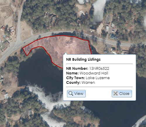
The map interface on the Search page and in the details modules displays various point and polygon layers. Most of these layers are scale-sensitive, meaning that you have to be zoomed in past a certain threshold for the layer to be visible. For some layers, clicking a point or polygon on the map will open a callout balloon with brief information about the associated record, as shown below for a National Register Building Listings polygon. This balloon may include a View button that allows you to view the record for that point or polygon.
Some layers require that you have archaeological data access privileges in order to view the layers or to open their associated records. To apply for archaeological permissions, please complete the PDF application form and email the form with supporting documentation (if applicable) to CRISHelp@parks.ny.gov with the subject “Archaeology Permission Request.” You will need to log into CRIS with an NY.gov ID account at least once before SHPO can enable archaeological permissions for your user profile.
The following layers are listed by their sort order on the map, with the layer sorted on “top” listed first. Each layer’s symbol and color scheme is shown in the Legend control to the left of the Layer List control.
Certain layers display by default, as indicated below. If you are an authenticated user, you can select which layers display by default using the Manage Map Layers option in your profile.
Point Layers
- Buildings: Displays by default. These are buildings, structures, objects, and above-ground sites that SHPO has inventoried. These are color-coded based on their eligibility for listing on the New York State Register and National Register of Historic Places. The View button in the callout balloon will open the USN details for the built resource. This layer is also available as an ArcGIS web service for use in GIS applications: Building USN Points
- SHPO Archaeology Sites: Displays by default for archaeological users only. These are archaeological sites that SHPO has inventoried. These are color-coded based on the site type (precontact, historic, human burials present, etc.). The View button in the callout balloon will open the USN details for the site.
- Submerged Resources: Displays by default for archaeological users only. These are submerged archaeological sites or shipwrecks that SHPO has inventoried. The View button in the callout balloon will open the USN details for the site.
- LPC Landmarks: Buildings, structures, objects, and above-ground sites that the New York City Landmarks Preservation Commission has designated as landmarks.
- NYS Museum Sites: Archaeological sites that the New York State Museum has inventoried. This layer is visible to archaeological users only.
- Cemeteries: Cemeteries that SHPO’s Archaeology Unit has recorded.
- DOT BINs: Bridges that the New York State Department of Transportation has inventoried. These are color-coded based on DOT’s evaluation of their eligibility for listing on the National Register of Historic Places.
Polygon Layers
- Building Footprints: The approximate extents of buildings in New York State, along with address information. This dataset is maintained by the New York State GIS Program Office using data from Microsoft, NYC Open Data, and New York State Energy Research and Development Authority (NYSERDA) in collaboration with the Center for International Earth Science Information Network (CIESIN).
- National Register Archaeology Listings: Displays by default for archaeological users only. These are archaeological sites and districts that are listed on the New York State Register or National Register of Historic Places. The View button in the callout balloon will open the National Register project details for the listing.
- National Register Building Listings: Displays by default. These are buildings, structures, objects, above-ground sites, and districts that are listed on the New York State Register or National Register of Historic Places. The View button in the callout balloon will open the National Register project details for the listing. This layer is also available as an ArcGIS web service for use in GIS applications: National Register Building Listings
- Archaeology Districts: Displays by default for archaeological users only. These are archaeological districts that SHPO has inventoried. The View button in the callout balloon will open the USN details for the district.
- Building Districts: Displays by default. These are historic districts that SHPO has inventoried. Historic districts are generally composed of buildings and structures, but they may include objects and sites. Historic districts with purple shading are eligible for the State or National Register; hollow boundaries indicate districts that are not eligible, are already listed on the State or National Register, or have not yet been evaluated by SHPO. The View button in the callout balloon will open the USN details for the district. This layer is also available as an ArcGIS web service for use in GIS applications: Building District USN Polygons
- Archaeology Surveys: Displays by default. These are areas that have been subject to archaeological investigations, often as part of the consultation process. For archaeological users, the View button in the callout balloon will open the survey details.
- Building Surveys: Displays by default. These are areas in which multiple built resources have been surveyed to determine which resources are eligible for the New York State Register and National Register of Historic Places. The View button in the callout balloon will open the survey details.
- Consultation Projects: Displays by default. These are areas that have been subject to SHPO review under the consultation process.
- LPC Historic Districts: Historic districts that the New York City Landmarks Preservation Commission has designated as landmarks.
- NYS Museum Areas: Archaeological areas that the New York State Museum has inventoried. This layer is visible to archaeological users only.
- Archaeological Buffer Areas: Buffer areas that are a specified distance around archaeological sites that SHPO has inventoried. Because these areas are only based on proximity to sites, locations within these areas may not be archaeologically sensitive, and locations outside of these areas may still be archaeologically sensitive. SHPO’s Archaeology Unit reviewers evaluate sensitivity based on a variety of environmental factors, including topography and hydrology, so these buffer areas are only suggestive. If you have questions about the potential archaeological sensitivity of a location, please visit SHPO’s Contact page to find the Archaeology Unit reviewer for the county. This layer is also available as an ArcGIS web service for use in GIS applications: Archaeological Buffer Areas
- Certified Local Governments: Municipalities in New York State that participate in the Certified Local Government program.
- State Commercial Tax Credit Program: Qualifying Census Tracts: Census tracts in New York State that may qualify for the state commercial historic tax credit program. Click a tract to display its qualifying status and tract number.
- Homeowner Tax Credit Program: Qualifying Census Tracts and Cities: Census tracts (or portions of tracts) in New York State that may qualify for the state homeowner historic tax credit program. Properties in certain cities may qualify for the program even if they are in census tracts that do not qualify. Click a location to display its qualifying status, tract number, and qualifying city (if applicable).
- State Park Land: Parks, historic sites, marine facilities, preserves, heritage areas, trails, and other properties managed by New York State Parks, Recreation and Historic Preservation.
- Adirondack Forest Preserve NHL Boundary: The extent of the National Historic Landmark for the Adirondack Forest Preserve. This includes state-owned tax parcels, state land areas classified by the Adirondack Park Agency, and 50-foot buffers around state road centerlines within the Adirondack Park boundary.
- Bedrock Geology: Geographic areas that are distinguished by their bedrock types, indicated by a code that is listed by the United States Geological Survey at https://mrdata.usgs.gov/geology/state/metadata/ny.faq.html#what.7.
- NY Congressional Districts: The United States congressional districts in New York State. Click within a district to display the name and party of the district’s representative.
- Minor Civil Divisions: New York State villages, towns, cities, and boroughs; also known as MCDs. Click within an MCD to display its name, type, county, 5-digit MCD code, and 6-digit Statewide Information System (SWIS) code. Some MCDs have additional notes about related municipalities.
