
CRIS is currently available to all users free of charge.
CRIS should be compatible with all up-to-date browsers, such as Chrome, Firefox, Safari, and Edge. If you encounter issues with a particular browser, please send details to CRISHelp@parks.ny.gov. To help us diagnose the issue, please visit What’s My Browser, copy the unique link shown on the page, and paste the link in your message. This link will identify your browser version and settings.
If the error prevents you from completing an action, send an email to CRISHelp@parks.ny.gov with the following information:
I attempted to draw my project boundary at Step 5 in initial consultation submission DF89HQQ4HFAK and received the following error message.
When you enter an address or intersection for a project or building location in CRIS, New York State’s Street and Address Maintenance (SAM) geocoder returns a ranked list of location results, and CRIS selects the top-ranked result. Sometimes the top-ranked result is not the intended location. Below are some tips that may help you get the correct result.
Guest users can access the basic functionality in CRIS. Authenticated users, who sign in with an NY.gov ID account, can access advanced functionality and can apply for additional privileges. Below is a table comparing the two user types and their available functionality.
| Functionality | Available to guest users? |
Available to authenticated users? |
|---|---|---|
| Create, view, and edit submissions | Yes | Yes |
| Primary contact information automatically entered in new initial submissions | No | Yes |
| Manage submissions and projects from a dashboard | No | Yes |
| View your project, including review status and correspondence | Yes | Yes |
| Add or edit project contacts | No | Yes(1) |
| Search and view building and district records | Yes | Yes |
| Search and view building surveys | Yes | Yes |
| Search and view National Register nominations | Yes | Yes |
| Search and view archaeological sites | No | Yes(2) |
| Search and view archaeological surveys | No | Yes(2) |
| Search and view all projects | No | Yes(2) |
(1) Your NY.gov ID email address must match the primary contact record in order for you to modify the project’s contact list.
(2) Requires advanced privileges. Contact CRISHelp@parks.ny.gov to request archaeological or project searching privileges.
OPRHP does not presently review or approve government and business NY.gov ID accounts. If you need to create a new NY.gov ID account to use for CRIS, SHPO recommends that you create a personal NY.gov ID account using your government or business email address. For more information about NY.gov ID accounts, please visit https://my.ny.gov/NYgovId/about.xhtml.
Visit the Forgot Username Self Service or Forgot Password Self Service page to recover or reset your NY.gov ID login information.
To change the email address for your CRIS user profile, you must first change the email address for your NY.gov ID account.
Sign into https://my.ny.gov and click Update My Account in the left sidebar. This will launch the NY.gov ID Account Update form in a new tab. In the NY.gov ID Account Update form, change your email address and click the Modify Account button. Click the Confirm button to save your changes. An alert will pop up: To the best of my knowledge, I have not willfully entered inaccurate information. Intentional violation may result in penalties and/or prosecution.
Click the OK button to confirm your changes and update your account.
The next time you sign into CRIS, your updated email address will be attached to your user profile. Be sure to click the My Profile link in the upper-right corner of the CRIS page to check that your information is up to date.
Search results are available for download as tables in the CSV (Comma-Separated Values) format. Photographs and attachments (including building inventory forms and National Register nominations) are also downloadable. GIS data cannot be downloaded from CRIS, but the following layers are available as ArcGIS web services that you can use in GIS applications:
For all other layers, you may request GIS data by contacting CRISHelp@parks.ny.gov.
Use the Spatial Search tools to zoom to your area of interest. If you wish to generate a list of State or National Register listings within a specific area, you may specify a search buffer or draw a search area. When you search the area, the listings will display in the Building NRs grid on the Results tab. Click the View (magnifying glass) button next to the listing in the Results tab to open the National Register Project Details module.
You can check whether a property is eligible for or is listed on the State or National Register with the following steps:
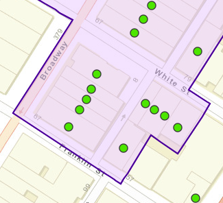
If the address is within a purple boundary, as shown in the image below, it is within a historic district that has been inventoried by SHPO (represented by a Building District USN). Historic districts with purple shading are eligible for the State or National Register; hollow boundaries indicate districts that are not eligible, are already listed on the State or National Register, or have not yet been evaluated by SHPO. In the image below, the green dots are National Register–eligible buildings, and the shaded purple boundary is a National Register–eligible historic district.
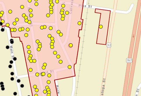
If the address is within a shaded peach area, as shown in the image below, it is either individually listed on the State or National Register, or it is listed as part of a historic district. In the image below, the yellow dots represent National Register–listed building USNs. If the address is in a historic district, you can check whether the building contributes to the district with the following steps:
If you are unable to find the property on the map or have further questions, please contact CRISHelp@parks.ny.gov.
The nomination form for a property that is listed on the New York State Register or National Register of Historic Places will be available for download under the Attachments (Atts.) tab in the National Register Project Details module. You can access this module in the following ways:
Multiple property listings and multiple property submissions, which include Multiple Property Documentation Forms (MPDFs), are groupings of historic resources that may be nominated to the National Register of Historic Places based on a theme or geographic area. More information about multiple property submissions is provided by the National Park Service in Chapter II of National Register Bulletin 16B, How to Complete the National Register Multiple Property Documentation Form.
Presently, you can view MPDFs in CRIS through the National Register Project Details module for one of the listings under the multiple property submission. Under the Nomination Data tab, click the Classification tab. Under that tab, next to Name of Related Multiple Property Listing, click the linked multiple property listing name to open the documentation PDFs.
If you do not know which listings were made under the multiple property submission, contact the Survey and National Register Unit reviewer for the region represented by the multiple property submission to ask for the MPDF.
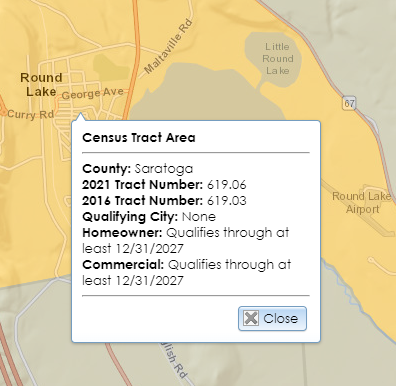
Use the Spatial Search tools to zoom to your area of interest. Open the Layers list in the map interface and toggle on the layers for the state commercial or homeowner historic tax credit programs. Properties in certain cities may qualify for the homeowner tax credit program, even if they are in census tracts that do not qualify. Click on the map to display a location’s qualifying status, tract number, and qualifying city (if applicable).
Use the Spatial Search tools to zoom to your area of interest. Open the Layers list in the map interface and toggle on the Archaeological Buffer Areas layer to view buffer areas around archaeological sites that are recorded by SHPO. Because these areas are only based on proximity, locations within these areas may not be archaeologically sensitive, and locations outside these areas may be archaeologically sensitive. SHPO’s Archaeology Unit reviewers evaluate sensitivity based on a variety of environmental factors, including topography and hydrology, so these buffer areas are only suggestive.
Access to archaeological data in CRIS is restricted to authenticated users who apply for and receive special privileges. To apply for archaeological permissions, please complete the PDF application form and email the form with supporting documentation (if applicable) to CRISHelp@parks.ny.gov with the subject “Archaeology Permission Request.” You will need to log into CRIS with an NY.gov ID account at least once before SHPO can enable archaeological permissions for your user profile.
National Register projects are searchable for all CRIS users. Searching for other project types, including consultation projects, requires privileges that are generally restricted to preservation personnel at state and federal agencies. To request project searching privileges, please contact CRISHelp@parks.ny.gov.
If you are trying to access your own project, you may open it with the Find My Project form on the guest user Home page or through the My Projects tab on the authenticated user dashboard.
Zoom to the polygon’s location on the Search page. Use the Spatial Search tools to search the polygons in that location. The list of polygons in that location will display in the Results tab.
There are several types of 12-character tokens that uniquely identify submissions and communication records throughout CRIS. Below is a list of these tokens, along with the places where you can find them and use them.
The instructions to continue a submission depend on the submission type.
Anyone can be a project contact, even if they are not an authenticated CRIS user. Authenticated CRIS users can receive more privileges, such as access to archaeological data or the ability to modify the project’s contact list if they are the primary contact. Project contacts may also use CRIS as guest users, but they will not have any additional privileges.
At Step 3 (Agency Information) in the Consultation Project Submission form, the primary and secondary agency pickers use a list maintained by SHPO. This list comprises state and federal agencies, as well as various grant and review programs.
SHPO recommends that you include any built resources that are more than 45 years old within the project area in your consultation project submission so that SHPO may evaluate their potential eligibility for the New York State Register and National Register of Historic Places. If your project only contains built resources that are less than 45 years old, please enter at least one in your submission.
Below is a list of each type of email message sent from CRIS, along with its list of recipients. The primary contact (or Trekker survey lead) will be in the email’s To: line, while all other contacts will be in the Cc: line.
If you are a registered CRIS user and you were the last person to edit the submission, sign into CRIS and go to the My Submissions tab on your dashboard. The submission’s status will be shown in the grid. You may need to switch the grid view from My Open Submissions to My Completed Submissions to see your submission.
If you are a guest user or you were not the last person to edit the submission, you may view the submission details—including its status—by using the View an In-Progress Initial Submission option on the Submit page.
If the submission’s status is Partial or Insufficient, it is not in SHPO’s processing queue. Please reopen your submission, ensure it is complete, and click the Submit to SHPO button to send it to the queue.
If you are the project’s primary contact and an authenticated user, you can add contacts to your project by opening the project details module, going to the Contacts tab, and clicking the Add Contact button.
If you are not the project’s primary contact or you are a guest user, email CRISHelp@parks.ny.gov to ask SHPO to add the contacts on your behalf. Be sure to include the project number and each contact’s name, address, phone number, and email address in your message. SHPO generally requires approval from the primary contact before modifying a project’s contact list.
Please note that cultural resource management consultants such as archaeologists do not need to be project contacts if they need to submit surveys or other additional project materials on your behalf. See the FAQ Does a third party (such as a consultant) need to be on a project’s contact list to submit additional project materials?
If you are a registered CRIS user and you are a designated project contact, sign into CRIS and go to the My Projects tab on your dashboard. You may need to switch the grid view from My Open Projects to My Closed Projects to see your project. Click the View (magnifying glass) button to open the project details. If you are a guest user, use the Find My Project form on the guest user Home page to open the Project Details module.
Under the Submissions tab in the Project Details module, the Submissions Overview tab will list the project’s submissions and reviewers, along with the due date and status of their reviews. You can expand a column by dragging or double-clicking the right edge of the column header.
If a submission’s status is Open, it is still under review. Any SHPO reviewers who have not yet signed off will have Incomplete next to their name. If a submission’s status is Closed, all SHPO reviewers have signed off on it. If you need to contact a SHPO reviewer, you can find their email address and phone number on SHPO’s Contact page.
For consultation projects, SHPO usually has 30 days to respond upon receiving a complete project submission. Some agencies or programs have a shorter review period. If a project has multiple submissions, SHPO’s total review time for the project may be longer than 30 days.
Tax credit submissions have 30-day review periods, which are counted from the date that SHPO receives a submission by mail.
Independent surveys, requests for evaluation of eligibility, National Register applications, and inventory form submissions do not have specific review periods.
The Esri application that is used for CRIS’s maps does not allow shapefiles or other GIS data to be uploaded directly to the map, such as for project or survey areas. However, you may attach a shapefile or file geodatabase to your submission in a .zip file. Please ensure that your GIS file adheres to the following guidelines:
.zip file (.shp, .shx, .dbf, .prj, and so on).The Esri application that is used for CRIS’s maps does not allow multiple polygons to be drawn for a single project. At Step 5 (Project Location) in the Consultation Project Submission form, select the most representative single area of your project and draw it. In your project area description, include a note that clearly states that the project covers additional areas. Upload reference maps for all project areas as one or more attachments at Step 4 (Project-Level Attachments). If you have GIS data that outlines the project areas, you can export the feature class to a shapefile, compile all shapefile components into a .zip file, and upload the .zip file as a project attachment at Step 4.
The file size limit is expressed in base-10 megabytes (1 MB equals 1 million bytes). Microsoft Windows represents bytes in binary multiples of 1024, rather than 1000. This means that the actual file size is larger than the figure shown in Windows.
Depending on the file format, you may be able to compress the file or divide it into multiple sections to be uploaded as separate files under the same submission. SHPO prefers this method over sending files on disc or as paper copies.
The following file formats may be uploaded for photos:
.gif.jpe / .jpeg / .jpg.pngThe following file formats may be uploaded for attachments:
.pdf (SHPO prefers this format for drawings, plans, and text documents.).zip (This format may be used to send compiled GIS or CAD files.).bmp.doc / .docx.gif.jpe / .jpeg / .jpg.mp3.png.ppt / .pptx.rtf.tif / .tiff.txt.xls / .xlsxWhen you submit photographs or attachments in response to a SHPO information request or through the Submit New Information for an Existing Project form, they will not yet be added to the project record, since the submission will be in SHPO’s processing queue. After SHPO accepts the submission and adds it to the project, the photographs and attachments will be added to the project automatically. If the files were uploaded to a built resource, archaeological site, district resource, building survey, or archaeological survey, then the files will be in those specific records after SHPO processes them.
If SHPO has requested the survey as part of its review of the project, you must submit the survey in response to a SHPO information request on the consolidated response page. SHPO strongly recommends that the consultant who prepared the survey is the person to submit it through CRIS, since the survey forms ask for specialized information. You or your consultant may access the survey request by clicking the link in the consolidated response email notification or by doing the following:
If SHPO has not yet requested the survey or you cannot locate the response token, please contact CRISHelp@parks.ny.gov or the appropriate SHPO reviewer with your project number and/or initial submission token.
Consultants and other third parties do not need to be project contacts in order to respond to SHPO information requests. You may forward the consolidated response email notification to a consultant. The email will contain a link to the consolidated response page where they may fulfill the SHPO request.
If the consultant submits a requested survey, the contact entered at Step 1 of the requested survey form will receive email notifications when SHPO receives the survey, sends it back for revisions, or accepts it to the project. After SHPO accepts the submission, the consultant will no longer receive emails for the project if they are not a project contact.
If a third party needs to submit unrequested information for the project, they may do so by entering the project number and the email address of an existing project contact in the Submit New Information for an Existing Project login form.
The Esri application that is used for CRIS’s maps does not allow multiple polygons to be drawn for a single survey. At Step 3 (Survey Area) in the archaeological survey form, select the most representative survey area and draw it. In your survey area description, include a note that clearly states that the survey covers additional areas. Be sure that the survey reports you upload at Step 5 (Report Documents) contain reference maps showing all areas. If you have GIS data that outlines the survey areas, you can export the feature class to a shapefile, compile all shapefile components into a .zip file, and upload the .zip file as an attachment at Step 5.