|
The boundary (polygon) of a proposed district can be modified/edited at any point until the district is approved by SHPO. Once the district is submitted to SHPO and approved, the boundary (as well as all other data) cannot be edited. To edit the boundary for a proposed district, from the Proposed District tab on the Survey details page (or on the Home page), click the View button to open the details page for the desired district.
Next, click the Edit Polygon button  in the upper right of the district details page. A confirmation dialog with several instructions is displayed. Click OK to dismiss the dialog and the district boundary polygon should appear with key points displayed as blue dots, and "break" points between blue points displayed as grey dots. Additionally, a dialog appears in the map display allowing the user to Complete the editing or Cancel. in the upper right of the district details page. A confirmation dialog with several instructions is displayed. Click OK to dismiss the dialog and the district boundary polygon should appear with key points displayed as blue dots, and "break" points between blue points displayed as grey dots. Additionally, a dialog appears in the map display allowing the user to Complete the editing or Cancel.
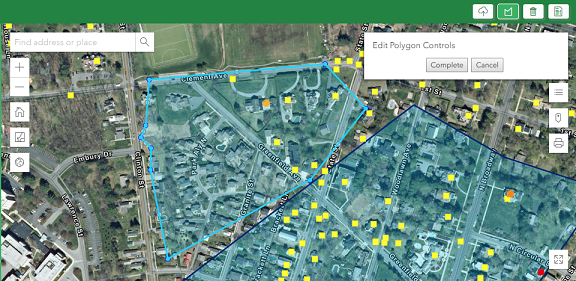
To reshape the polygon the user can use the following methods:
•Hover the mouse over a blue dot (wait until it highlights by slightly expanding in size) then press/hold the mouse and drag to the desired new location;
•Press/hold the mouse on a grey break point and wait a split second, then drag the break point to the desired new location. Note: When a grey break point is moved, it becomes a blue dot, and 2 new grey break points are created on either side at the mid point between itself and the neighboring blue dots.
•To drag the ENTIRE polygon in a given direction, press and hold the mouse anywhere inside the polygon and drag in desired direction
Note: Be careful not to accidentally drag the entire polygon instead of reshaping a point along the boundary. Zoom in close enough to be sure you are on top of the point to be reshaped.
When done editing, click the Complete button in the dialog to accept the edits and save the polygon (or to cancel without saving any polygon edits, click the Cancel button or the Edit Polygon button).
Note: When a district polygon is edited/re-shaped, the district field of all building inventory forms within the current survey project are automatically recalculated to determine which buildings are within the district.
|